Tour of the Tre Cime di Lavaredo
The excursion starts from the Auronzo Refuge, reachable from Misurina in about ten minutes by car along the two-lane asphalt road (16% gradient!!), with a toll fee (20€ per car), which allows you to reach the refuge without starting the loop with a 'climb' of 500 metres of elevation gain starting from Misurina.
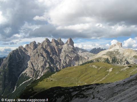
The entire route, which, circling around the Tre Cime di Lavaredo, allows you to enjoy their immense beauty from a large number of observation points, winds entirely above the upper limit of the forest, along scree slopes crossed by dirt roads and comfortable paths.
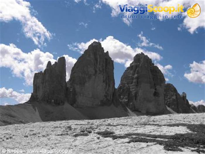
From the Auronzo Refuge (2320 m), from where you enjoy a wide panorama towards the Ansiei Valley and Auronzo di Cadore, the Catini di Misurina (2839 m), Lake Misurina and Lake Antorno, the Sorapiss (3205 m) and Monte Cristallino di Misurina (2775 m), you take path 101, a dirt road that, with a flat course, leads to the Lavaredo Refuge (2344 m). Walking at the foot of the south face of the Tre Cime after about fifteen minutes you reach a small church, the Cappella degli Alpini, dedicated to Maria Ausiliatrice and, nearby, a stele commemorates Paul Grohmann, pioneer of the climbs on the Dolomites. In front you can see the Croda dei Toni (3094 m) and, when the road turns left, the Croda Passaporto (2701 m) also appears.
Having reached the Lavaredo Refuge you go up towards the Forcella Lavaredo (2454 m), one of the two points of the route where you have to work a bit harder (but not too much given the mere 110 metres of elevation gain). Arriving at the top of the notch, the highest point of the excursion, we are at an important observation point over inimitable mountain landscapes: on the left the Tre Cime di Lavaredo rise majestically, which from here can be admired up close and, in front, a large number of mountains opening like a crown, among which, the closest are Monte Rudo (2826 m), the Croda dei Rondoi (2859 m), the Torre dei Scarperi (2687 m), the Monte Mattina (2464 m), the Torre di Toblin (2617 m) and the Sasso di Sesto (2539 m) at whose foot you can make out the A. Locatelli Refuge, while on the right rises Monte Paterno (2619 m) and again the Croda Passaporto (2701 m).
On the left, the walls of the Cima Piccola where you can clearly see, with the use of the indispensable binoculars, the climbers busy scaling the peak.
From here you can decide to continue the excursion towards the Locatelli Refuge, or extend it by about 2.5 hours by taking path 104 which leads to Pian di Cengia, circling Monte Paterno and then reaching the Locatelli Refuge from the east by resuming path 101.
We decide to head directly to the Locatelli Refuge. Having descended from the notch it is possible to follow 2 different routes: the first follows the scree along the slope with some ups and downs to reach the Locatelli Refuge directly; the second descends about 50 metres from the notch and after a climb leads to the Locatelli Refuge (2438 m), located on the Forcella di Toblin. Straying slightly from the Refuge towards the ridge on the right, you see the Alpe dei Piani with the two Laghi dei Piani and beyond, towards the valley, the narrow Sassovecchio Valley descending towards the Fiscalina Valley and Sesto di Pusteria. On the left of the Sassovecchio Valley rises the Crodon di San Candido (2891 m) and on the right the Cima Una (2698 m).
We are halfway through our excursion and the plateaus surrounding the refuge make this place ideal for a packed lunch, avoiding the astronomical prices of the refuge (1.5€ for a coffee, 3.6€ for a slice of Strudel!!). You will be the guests of the numerous alpine choughs and if you are lucky of the raven, the largest corvid of the Dolomites.
Behind the Refuge, in a slightly higher position, there is a small church that commemorates the fallen of the bloody battles fought among these wonderful mountains. From here it is possible to add a small variant to the route to climb the Sasso di Sesto. It is a simple path that leads in 1 hour or a little more to enjoy a breathtaking view over the north face of the Tre Cime and over the entire Sesto Dolomites area, without all the din and the multitude of people crowding the refuge. Recommended!!
From the Refuge you continue descending along the path to the right as you look at the Tre Cime di Lavaredo, the 105. The first stretch is slightly downhill, which steepens after the first fork where you continue to the left, following the signs for the Auronzo Refuge until reaching Pian da Rin, where the "anti-springs" of the Rienza River are located. The water of the spring flows for a short stretch, then disappears again underground, to reappear much further down the valley, where the true sources of the Rienza River are located, a left tributary of the Drava River, which pours the waters of the Tre Cime di Lavaredo into the Danube and then into the Black Sea.
From here begins the most 'demanding' stretch of the entire excursion: you climb for a good stretch along the path which, first with an almost constant gradient and then in continuous gentle ups and downs, reaches the Col Forcellina. Continuing along the path which continues with an up-and-down course, you cross a small stream whose waters come from one of the three small lakes further upstream and, as soon as you start climbing again, you reach the Malga Longa, where you can take a break and buy cheese, milk and mountain yoghurt.
From here climbing for a short stretch on the left you see the three little lakes of the Tre Cime. The landscape you cross, always in the presence of the Tre Cime di Lavaredo, is fantastic. In some points where the hikers 'scatter' and we manage to remain a bit isolated, the imposingness of the very close and majestic Peaks and the 'deafening' silence that surrounds us makes this place almost mystical.
Having reached the summit point of the climb, the path continues along a stretch with a flat and slightly uphill course, cutting across a large scree slope, at the end of which you reach the Forcella di Mezzo, where the path splits. From here, following the left path you face the last short stretch of the excursion, where with a continuous gentle up-and-down you also cross a point where the outcropping rock is constantly wet and slippery, and where, for greater safety of the hiker, a short chain has been placed to hold on to. Nothing transcendental, nothing to fear;-)
After about four hours of walking you see the Auronzo Refuge again, from where you can pick up the car to return down to the valley carrying in your heart and mind one of the most beautiful landscapes of all the Dolomites!




3 reader comments
foto splendide e commento dettagliato! sempre più che perfetto il kappone!
grazie grazie :-D Le dolomiti sono una cosa fantastica, sia d'estate che d'nverno. Ti riempiono il cuore!
Che belle foto Kappa, mi hai ricordato uno dei posti nelle Dolomiti cui più sono affezionato! Da consigliare a chiunque questa gita, richiede piccoli sforzi e dona grandi emozioni.