The story
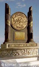
The Pillars of Hercules too — that is, the Strait of Gibraltar — just like the passage between Scylla and Charybdis, had given rise to a legend built around the deeds of Hercules, Heracles in Greek. He had been given the task of recovering the herds of Geryon, which the shepherd Eurytion guarded on the island of Erytheia, at the edge of the West. On the outward journey he had freed Libya from a multitude of monsters and, in memory of those deeds, had erected two pillars, on both sides of the Strait, at Ceuta and on the opposite shore, near Gibraltar.
Indeed, according to the legend, when he passed from Africa to Spain and reached the island of Cadiz, he built a tall tower there on which he raised a statue facing east, with a key in its right hand, as if to open a door; on the left he instead carved the inscription 'Here are the boundaries of Hercules', marking the impassable limit of the known lands. The ancient tales were taken up in cartography from the Middle Ages until the sixteenth century: on many medieval world maps the 'Pillars of Hercules' were placed near the Strait, but as navigators pushed further into the Atlantic, the pillars were moved on the charts as far as the lands reached last, thus marking the boundaries of the known world.
The journey's photographs
4 photographs · click to open them full screen


0 reader comments